While we were talking, the Western Oil Company excavator carried the empty gas tank and placed it on a large flatbed trailer; it was about to be hauled away by dump truck to Exeter Scrap Metal. I went home to get my camera, but the truck had already left by the time I got back. I followed the old tank to Exeter Scrap Metal, which recently moved a quarter-mile north of their old location, with a green metal scorpion out front that should give the “Big Blue Bug” in Providence a run for its money (above). The scrap yard folks were kind enough to let me photograph the old gasoline tank in its new digs (below, tank circled).
When I came back to the excavation site, the engineer from Resource Controls was discussing his soil samples with Angela Harvey, an engineer from DEM. She introduced herself to me and I told her I was from WRICHS with a historical interest in the business that had once been located there. She mentioned that the road we were standing next to was actually not an older section of Route 3, but rather was once known as Kitts Corner Road (left). When I asked Ms. Harvey about the former proprietors, like everyone I had spoken with she did not know who had operated the station or when it went out of business.
Then I mentioned that it may be possible that RIDOT’s bridge authority, which has an extensive photographic archive documenting state bridge-building for over a century, would have documented the construction of the nearby bridge over the Big River (this RIDOT photo archive was one the topics covered in “Over the River and Through the Woods: Bridges, Highways, and Public Works,” a workshop put on at the recent Rhode Island Preservation Conference in West Warwick in April 2013). Though the ceramic name and date tiles are no longer extant on the bridge (in fact, the bridge seems to be deteriorating rather badly at this point), it was almost certainly built in the latter 1930s during the Great Depression as part of the WPA. Maybe the bridge-building photos captured, off in the distance, an image of the gas station.
At that point Ms. Harvey told me about a historical resource I was not aware of. DEM has an extensive archive of aerial photographs of the entire state that date back to 1939, catalogued online using a GIS (Geographic Information System) program. I gave her my card and she agreed to send me information pointing me to DEM’s aerial photograph site. As promised, the next day she sent me a link to http://www.dem.ri.gov/maps. Her email instructed me to
“[s]imply scroll down to the fourth map selection (Topo Map & Aerial Photo Viewer), which will take you into the GIS program. Once you enter the viewer, type your address into the “find places” space located at the top right corner of the screen.”
I was able to navigate the map to the gas station locale simply by zooming in with my mouse wheel. On the upper left menu, by clicking the > symbol, the layers of the GIS map appear as a list. The default map that first appears is the “2011 Color” aerial map of Rhode Island; when the menu boxes for earlier maps are checked, the more recent map will gradually be replaced by the earliest map checked.
These aerial maps are a very intriguing resource. I have spent some time of late exploring the transformation of different parts of the state. Is some places, fields have turned into forest, while in many others the forest has been converted into houses and shopping centers. I recommend everyone go there and look at how much your neighborhood or other familiar locales have changed over the past 70 years.
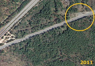
These maps help answer some but not all of the questions regarding the gas station on Route 3. The journey back in time starts with DEM’s default map from 2011 – the area where the gas station was once located is circled. With the next image, we go back to 72 years, to 1939. Route 95 disappears, along with Big River Road, the road running parallel to 95 South on the 2011 map. Further to the west, Weaver Hill Road met directly with Kitts Corner Road to connect the hinterland with Nooseneck Hill Road. Focusing in on that triangular intersection, it appears to be heavily wooded – there is no gas station there or any other business, just woods – in 1939. A house can be seen in the photo in the cleared lot due west of the wooded triangle. Today, the lot is empty but still there is still a stone retaining wall running parallel with Route 3 where the house once stood.
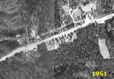
The next set of aerial maps is from 1951. In this image, the gas station appears as a large square building casting its shadow to the north, in the triangle at the intersection of Nooseneck and Kitts Corner, about the same size as the house to west behind the retaining wall. Zooming out on the website map, it is clear that for many people living in the hinterland of West Greenwich, the best road out to Route 3 north was Kitts Corner Road. This gas station was likely the first one folks from the hinterland would pass on their way to work in the morning and last one they would go by on their way home. What about the residents of the house next to the station? Were they the proprietors of the station? Or did they lease or sell the triangle lot to a local mechanic or a franchise? There is no way to identify any details about the business from this image. Based on the size of the building, the station quite probably had a service bay to provide auto repairs; most gas stations at that time did that along with selling fuel, unlike today’s gas stations that only sell gas. Since the station was not in the 1939 aerial photographs, and due to gas rationing during World War II, it is also a safe bet to guess that the station was built sometime between 1945 and 1951. The business relied on travelers from Kitts Corner Road heading out to Route 3, which was at that time the main road through western Rhode Island to get to Providence, and to provide auto repairs to folks that might have broken down along Route 3. This probable construction date of after the war would also make it unlikely that any of RIDOT’s Depression-era photos of the construction of the Big River Bridge would incidentally show us more detailed images of the service station than the DEM aerial photographs.
In the aerial images from 1962, the arrival of Route 95 makes a profound change on the landscape. Kitts Corner Road, like many local roads and farms along the path of the interstate, is cut in two. The gas station building is still there, though it is impossible to tell from the photo whether it is still in operation. Further south outside the frame of the above photo, Route 3 and Route 95 become one for the next several miles south. In the next image ten years later (below), the gas station is clearly no longer in existence, though the outline of the parking lot is much clearer than in earlier images. The house in the lot due west of the former gas station is still there, though whether anyone was living there still is impossible to determine. Further south, Route Three and Route 95 were also separated out and ran parallel to each other rather than being combined together. As a commuter who uses Route 95 southbound to get to work, I can speak to the importance of having a second, parallel route to take when an accident has closed the interstate and the highway is backed up for miles.
By 1972, according to the April 2013 RIHPHC workshop, Route 95 had become a limited access highway; a bridge now carried the interstate over Weaver Hill Road, which became the new access point for the West Greenwich hinterland to reach Route 3, and access to 95 from Kitts Corner Road was closed off. As a youngster, I remember my father being able to get on and off the interstate at Switch Road in Richmond, but that at some point the state put up guardrails and berms to prevent people from getting on and off the highway from any of the old roads that once crossed Route 95. The only way to access the highway was at the numbered exits with on and off ramps. To this day, my father (who turned 88 back in March) still argues that Route 95 “ruined the area” by making it difficult for people in the vicinity of the highway to get around their own neighborhoods. But in the early 21st century, with the tremendous amount of infrastructure and bridge repair that needs to take place, we are probably fortunate that every minor laneway in use one hundred years ago was not given a bridge to go under or over the path of Route 95.
So the mystery remains. Who owned this gas station? Did the business fall prey of Route 95 and the attendant decline of traffic on Route 3 as a result of the people using the interstate to get to Providence? With far fewer cars going by on Nooseneck Road and none at all coming down Kitts Corner, this intersection was certainly no longer the “central place” it once was and may have lost its economic viability. But there is another possibility: the Big River Reservoir. The state first began consideration of damming the Big River to create another vast public water supply like the one in Scituate as far back as the 1920s. In the 1960s, at exactly the same time that the federal government was finishing the interstate highway system, Rhode Island began moving ahead with another major engineering project right in the same area as our mystery gas station.
“In 1964, the General Assembly, under the Big River-Wood River Acquisition Act, established a requirement for a bond issue of five million dollars…to be placed on the general referendum ballot. Having recently experienced the inconveniences and health hazard associated with several drought seasons, the voters passed the bond referendum. Under the powers of eminent domain, the state began acquiring property by condemnation beginning in Coventry in 1965, West Greenwich in 1966, and the in the Wood River area in Exeter in 1967…In the end, the state obtained a total of 8,600 acres from 351 owners which comprised 444 parcels at a cost of $7.5 million…”
--Excerpt from RI WATER RESOURCES BOARD,
BIG RIVER MANAGEMENT AREA POLICIES, July 1997
Either way, it seems that this gas station was not destined to remain in business into the 1970s. Today, Kitts Corner Road is just one of thousands of old back roads across the US impacted by directly or indirectly by the arrival of the interstate – once economically vital thoroughfares that are now bucolic roads to nowhere (below).


