Thursday, June 23, 2016

Summer 2016: Jetsam and Flotsam

             Photograph I took of Block Island Sound from Crescent Beach on Block Island last Sunday (Father's Day 2016)

Such is the nature of a life of being a parent, a teacher, a homeowner cat owner and a fellow human -- there are not ever enough hours in the day! I have several times since my last post contemplated writing a new one but have always been distracted by...one of the above. It doesn't help that I am a bit of a perfectionist...a fellow (and far more prolific) blogger friend has suggested I just write every day and be less concerned with how perfect it may or may not be. Anyway. Time may be infinite but life is not, and being a parent, quality of life and the vortex of teaching take priority over daily blogging...


Now that I am on summer "vacation" I can get back to all the history projects that have been in various stages of limbo since -- in some cases last summer or even the summer before. Not to mention nurturing another creative outlet by dusting off the guitars, saxophones, basses and music editing/composing software on the computer. Another important summer goal is not to fall behind on Season 7 of Adventure Time and to catch up on the last two seasons of Game of Thrones and Veep. And for my inner geek, I should finish re-watching Babylon 5 and John Carpenter's Apocalypse Trilogy...

And the beach. Definitely going back to that beach.


So, first some news. Congratulations to Erica Luke and the folks at the former Pettaquamscutt Historical Society for all their hard work leading up to the grand re-opening of PHS as the South County History Center! (Love the new logo btw!!) Everyone in southern New England (and Governor Raimondo's former marketing staff) should definitely check out "Cooler & Warmer: Poring Over the Drinks of Rhode Island," the Center's current exhibit (2636 Kingstown Road, Kingston, RI), in the main gallery at the Old Washington County Jail from May 21 - August 31, 2016.


Also congratulations to the Western Rhode Island Civic Historical Society for running a great Flag Day program at the Paine House Museum on June 14 that included both the Korean War Veterans and local Girl Scouts in celebration of the 1777 US Flag Resolution. Inara completed four out five goals for her Community Merit Badge, which (after she marches in a parade) will be her tenth Brownie merit badge!


History Camp Boston on March 26, 2016 at the Harriet Tubman House was a great success -- kudos to Lee Wright for once again organizing a great day of public history in Boston. The event sold out for the third year running!

The Unconference approach is such a great format that this year History Camps are happening not just in Boston but in Des Moines, Iowa, in the Pioneer Valley in Holyoke, MA and Denver Colorado! I had a lot of fun giving one presentation on Roman Britain and another on the landscape history of Rhode Island and Connecticut over the last 500 or so years. Now that I have some "free time" lol, I need to do some minor editing and upload both sets of presentation slides to the History Camp website...


Summer reading list...I just finished Michael Wolraich's Unreasonable Men: Theodore Roosevelt and the Republican Rebels Who Created Progressive Politics for the GoodReads History Book Club -- highly recommend it to anyone looking to read something good, informative but not "heavy." Have also ordered Andrew Jackson O'Shaughnessy's The Men Who Lost America: British Leadership, the American Revolution, and the Fate of the Empire and Annette Gordon-Reed's The Hemingses of Monticello: An American Family. While waiting for Amazon to deliver those in the next couple of days, I have begun reading Riad Sattouf's graphic memoir The Arab of the Future. And I am also re-reading Thinking Like a Historian: Rethinking History Instruction, with the aim of redesigning my US History class almost entirely around Thinking Like's inquiry-based approach. Going to flip my classroom using NearPod to deliver textbook and vocabulary content and for formative assessment, and use the Thinking Like approach to guide the core work students will do in the classroom of interrogating primary and secondary sources to answer these questions:


And last but not least, writing and research. I have a Model Legislature 2.0 grant to write and submit to the Rhode Island Council for the Humanities by their August 1st Civics Mini-Grant deadline. Next stage: find a video production company to help us create the training modules for our website! Louise Oliveira (my fellow statewide coordinator for the program) and I also met this past Tuesday with Lane Sparkman, the Education Director for Nellie Gorbea, the RI Secretary of State, to talk about the trials and tribulations of the Rhode Island Model Legislature program. Great meeting -- nice to know we have a secretary of state who is an avid supporter and promoter of civics education! Then I have several oral history interviews on the agenda for the WRICHS Archive, as well as the ongoing organization of the archive there. I am a good part of the way through writing an article for Christian McBurney's Online Review of Rhode Island History (smallstatebighistory.com) about the way Rhode Island courts, towns and the provincial/state government responded to outbreaks of the smallpox virus in the 17th and 18th centuries. Christian also invited me and his blog's regular writers to take part in a new project called "Presidents in Rhode Island" (fairly self-explanatory). I am interested digging into TR's speech at Newport's Naval War College and LBJ's visits to RI college campuses in the Sixties.


And finally, this week I was called upon by the folks at the South County History Center to answer a question regarding South Kingstown's reaction to the Tea Act in 1774. As it happens, while researching my graduate thesis I had created a digital set of town records with an old Canon A630 (God I loved that camera, may it rest in peace!), and I also transcribed many pages of those meeting records into a Word document so I could do file searches. It didn't take me long to find the information the SCHC was looking for. I didn't even have to get out off the couch!


But this brief foray back into my old research has re-awoken my interest in the long-dormant journal article summarizing the findings of my MA thesis concerning the political rivalry between South Kingstown and Providence from 1760 to 1850. This was a project at the top of my "to-do" list after I finished my MA, but instead of working on that for some reason I busied myself with the next several projects on the list. I have been avoiding the thesis publication re-write I think because I was just too close to the living breathing all-consuming research-writing-defense-revision process (horror?), that I just couldn't look at it anymore. I. Just. Couldn't.

But I successfully defeated the snake five years ago this July 27...submitted my revised thesis and graduated four years ago...I think I can to go back in there now and objectively do this.

Friday, January 1, 2016

Happy New Year, 2016!


HUZZAH! The earth has successfully completed yet another orbit around the sun, to add to the 4.54 (± 0.05) billion or so already completed and Alas! it is another new calendar year. The last few months have been especially busy, as evidenced by the not-much-blogging-taking-place around here (I do post interesting items I run across fairly regularly on Twitter though, @HistoryGardner It is like a mini-blog of History Garden type stuff, so if you haven't checked it out and are looking for some new history content, follow me on Twitter!).

Rest assured, new content will be posted in the new year. Boston's HistoryCamp 2016 is coming up March 26, and I will posting my presentation ideas/drafts here before March (I hope)!

In the meantime, here are some postcards courtesy of the The Compass Point from 100 years ago in celebration of the then new year, 1916, some with cheerful themes and others, somber reminders of World War I. Then entering it's third year, some of the most brutal battles of the Western Front were to be fought later that year...


Saturday, September 12, 2015

Upcoming Events September-October 2015

Some really interesting history-related events coming up in the next couple months! As I find more I will edit this post, but for starters, here are events sponsored by the Pettaquamscutt Historical Society, the Rhode Island Historical Society and lectures by historian Christian McBurney, author and founder of The Review of Rhode Island History, an online journal of Rhode Island History.

But first, I would also like to take this opportunity to send my heartfelt best wishes to Old Colony Historical Society Archivist, Coventry Historic District Commission Chairman and former Director of the Paine House Museum Andrew D. Boisvert, who is leaving for Washington DC on October 1! Good luck Andrew! Your history shirts and enthusiasm for documentary evidence and material culture will be missed!

Andrew Boisvert, April 2014

Next, I would like to announce that the Pettaquamscutt Historical Society will be making a VERY IMPORTANT ANNOUNCEMENT at the Narragansett Towers on October 5, 2015.

Join PHS as we make history!

Also, Pettaquamscutt Historical is open these days through December 19, 2015:
  • Wednesday 11 a.m. - 4 p.m.
  • Thursday 11 a.m. - 4 p.m.
  • Saturday 11 a.m. - 4 p.m.

And now, The Events.

Author Lecture: Spies in Revolutionary Rhode Island by Christian McBurney
Sunday September 13, 2015 at 2 p.m. Babcock Smith House Carriage House, 124 Granite Street, Westerly, RI. Sponsored by the Westerly Historical Association.

"Espionage played a vital role during the American Revolution in Rhode Island. The British and Americans each employed spies to discover the secrets, plans and positions of their enemy. Author Christian M. McBurney unravels the world of spies and covert operations in Rhode Island during the Revolutionary War." (Excerpt from Amazon.com review)

Public Lecture: Fort Kearney, Top Secret WWII German POW Camp, by Christian McBurney and Brian Wallin
Wednesday September 16, 2015, 4:30 p.m. at the URI Bay Campus Coastal Institute Auditorium, Saunderstown, RI.
RSVP to Rhode Island Sea Grant at (401) 874-6800 or rhodeislandseagrant@gmail.com to reserve a seat, though reservations not necessary. (This event has already received some nice press.)

Public Lecture: "Remembering the Great Gale" by Robert P. Emlen, Brown University Curator and Senior Lecturer in American Studies
Wednesday September 16, 2015, 6:30p.m. at the Aldrich House, 110 Benevolent Street, Providence Rhode Island

"On a Saturday morning in 1815, 11-foot-plus storm surges blasted the coast of Rhode Island, driven by what experts believe was a Category 4 hurricane originating in the West Indies and making landfall in New England.Scores of ships and hundreds of buildings were destroyed, and the Providence waterfront itself suffered rampant damage amounting to an estimated quarter of the city's total valuation at the time. Although few lives were lost in Rhode Island, a total of 38 New Englanders are reported to have died in the storm. Join Robert Emlen for a look back on the two hundredth anniversary of this natural disaster."

Tickets are $10; $5 for RIHS and Historic New England members'. Advance purchase is required here or by calling (401) 728-9696.

Author Talk: Kidnapping the Enemy: The Special Operations to Capture Generals Charles Lee & Richard Prescott by Christian McBurney
Thursday September 17, 2015, at 6:00 p.m. at The Mary Elizabeth Robinson Research Center (formerly known as the Rhode Island Historical Society Library), 121 Hope Street, Providence, RI. Sponsored by the John Russell Bartlett Society.

"Christian McBurney relates the story of these remarkable raids, the subsequent exchange of the two generals, and the impact of these kidnappings on the Revolutionary War. He then follows the subsequent careers of the major players, including Lee, Barton, Prescott, and Tarleton. The author completes his narrative with descriptions of other attempts to kidnap high-ranking military officers and government officials during the war, including ones organized by and against George Washington. The low success rate of these operations makes the raids that captured Lee and Prescott even more impressive." (Excerpt from Amazon.com review).

Walking Tour: Remembering The Great Gale of 1815
Saturday, Sept. 19, 2015 3:00 p.m. – 4:30 p.m., starting from The John Brown House Museum, 52 Power Street, Providence, RI 02906

Barbara Barnes (RIHS Tourism Services Manager) and Dan Santos (Historic New England Regional Site Manager for Southern New England) will lead a fascinating tour visiting the very places in Providence that bore the impact of the Great Gale of 1815. This special event will take participants back in time to a major moment in Rhode Island history.

Tickets are $10, and registration is required by emailing bbarnes@rihs.org or by calling (401) 273-7507 x2.

Author Talk: Kidnapping the Enemy: The Special Operations to Capture Generals Charles Lee & Richard Prescott by Christian McBurney
Saturday, September 19, 2015 at 10:00 a.m., Winslow House, 634 Careswell Street, Marshfield, Massachusetts.

Author Talk: Spies in Revolutionary Rhode Island by Christian McBurney
September 19, 2015, Saturday, at 2:00 p.m.: Atria Aquidneck Place, 125 Quaker Hill Lane, Portsmouth, RI.

The 2015 Newell D. Goff Lecture: "514 Broadway: A&L Tirocchi Gowns and the American Dream" by Museum of Fine Arts Boston Curator Pamela Parmal
Sunday, Sept. 20, 3:30 pm, Aldrich House 110 Benevolent Street, Providence Rhode Island

"The Tirocchi sisters and their employees produced exquisite dresses for high-society women in the early 20th century and left an unparalleled archive of garments, fabrics, ledgers, photographs, and correspondence. This talk is presented as part of the RIHS's Rhode Island by Design series for 2015, highlighting the role of design in Rhode Island history.

Strong demand for seating is expected, and RSVPs are required. Click here to reserve admission, email programs@rihs.org, or call (401) 331-8575 x136!

Public Lecture: Voices from the Back Stairs: Domestic Servants in New England by Historic New England museum historian, Jennifer Pustz
Monday, September 21, 6:30 - 8:30 p.m. at the Governor Henry Lippitt House Museum, 199 Hope Street, Providence, R.I. Doors open 6:30 pm, lecture begins 7:00 pm. Light refreshments to follow.
$5.00 Historic New England and Preserve Rhode Island members; $10.00 nonmembers; buy tickets online here or call 617-994-6678.

Although domestic servants made everyday life in grand homes possible, their identities and roles within the household have long been hidden. A lecture by Jennifer Pustz, museum historian at Historic New England, illustrates the diversity of domestic service in New England over the nineteenth and twentieth centuries.

Smithsonian Museum Day Saturday, Sept. 26, 2015

  • Pettaquamscutt Historical Society
    11 a.m. - 4 p.m. at the Old Washington County Jail with free family friendly tour and activities

  • Heritage Day Western Rhode Island Civic Historical Society
    At the Paine House Museum Station Street, Coventry RI 02816, with free tours of the Paine House, hot dogs, johnny cakes, yacht soda, games and colonial-era crafters providing public demonstrations of their trades.

  • Museum Day Live! Rhode Island Historical Society (Smithsonian Affiliate)
    Free admission to: the John Brown House Museum 52 Power Street, Providence RI and the The Museum of Work & Culture 42 South Main Street, Woonsocket Rhode Island.
    This event will help launch "What Cheer Wednesdays," an experimental program with a pop-up sensibility featuring rotating weekly offerings, as well as chats with curators, docents, and educational staff. What Cheer Wednesdays will also feature free admission, starting September 30, 2015.

Author Talk: The Spirit of '74: How the American Revolution Began by Ray and Marie Raphael
Wednesday, September 30, 2015 7:00 p.m. at the Worcester Historical Museum, 30 Elm St, Worcester MA 01609

The Spirit of '74 is the story of what happened between the Boston Tea Party in December of 1773 and the battles of Lexington and Concord in April of 1775, detailing how vitally important those sixteen months were to the overthrow of British rule and the founding of our nation. Worcester and Worcester County played key roles in this history that is often overlooked in standard narratives of the American Revolution. Worcester county militiamen from 37 different towns shut down the Royal Courthouse on September 7, 1774, in the largest peaceful display of civil disobedience at that time. This effectively ended British authority in the rural sections of Massachusetts. Worcester was also the center of military activity with the largest store of guns and ammunition in the colony. In fact, General Gage considered sending troops to seize these stores, but realized that the people of Worcester would put up too much of a fight and his troops would not be able to return safely to Boston. He chose instead to seize the stores held at Concord.

Ray Raphael is the author of seventeen books, including The First American Revolution, which details the closing of the courts in Worcester. Marie Raphael is the author of two historical novels and has taught literature and writing at Boston University, College of the Redwoods, and Humboldt State University.

Author Talk: Kelly Sullivan Pezza
Murder & Mayhem in Washington County Rhode Island

Saturday October 3 at 2 p.m. at the Old Washington County Jail

"Rhode Island’s Washington County hides a dark past riddled with macabre crimes and despicable deeds...author Kelly Sullivan Pezza is a native of Hope Valley, Rhode Island, and has worked as a journalist for southern Rhode Island newspapers for seventeen years. With an education in law enforcement and many years of experience as a Rhode Island historian and genealogist, she has written hundreds of articles and several books concerning historic true crime and unsolved mysteries in Rhode Island." (Exerpt from Amazon.com review)

Author Talk: Cynthia Johnson, James DeWolf and the Rhode Island Slave Trade
Wednesday October 7 at 6:30 p.m. at the Kingston Free Library's Potter Room
Co-Sponsored by PHS and Friends of Kingston Free Library

"Over thirty thousand slaves were brought to the shores of colonial America on ships owned and captained by James DeWolf. When the United States took action to abolish slavery, this Bristol native manipulated the legal system and became actively involved in Rhode Island politics in order to pursue his trading ventures. He served as a member of the House of Representatives in the state of Rhode Island and as a United States senator, all while continuing the slave trade years after passage of the Federal Slave Trade Act of 1808. DeWolf's political power and central role in sustaining the state's economy allowed him to evade prosecution from local and federal authorities--even on counts of murder. Through archival records, author Cynthia Mestad Johnson uncovers the secrets of James DeWolf and tells an unsettling story of corruption and exploitation in the Ocean State from slave ships to politics." (Amazon.com review)

Public Lecture: “Villages, Maize, and the Narragansett: New Information on the Formation of a Traditional Indian Territory along the Rhode Island Coast” by Joseph N. Waller, Jr., PAL
Joseph Waller, Jr. of the Public Archaeology Lab will discuss the excavations at the Salt Pond archaeological site, also known as RI 110
Tuesday October 13 at 7 p.m. at the URI Bay Campus Coastal Institute Auditorium, Saunderstown, RI.
Co-Sponsored by the Pettaquamscutt Historical Society and the Tomaquag Museum

Public Lecture: "Unfortunate Ends: Gleanings from the Death Notices of Early Rhode Island Newspapers" by historian Robert Geake
Wednesday October 14th at 7:00 p.m. at the Warwick Public Library, 600 Sandy Lane, Warwick, Rhode Island. Sponsored by the Warwick Historical Society


Pettaquamscutt Historical Society: Lanterns & Legends Tours
At the Old Washington County Jail, Kingston RI
  • Thursday, October 15, 6-9 p.m.
  • Saturday, October 17, 6-9 p.m.
  • Thursday, October 22, 6-9 p.m.
  • Saturday, October 24, 6-9 p.m.
  • Thursday, October 29, 6-9 p.m.
Tickets available on Eventbrite soon!

Public Lecture: “The South Kingstown Quakers Meeting House Fire of 1790: The Application of Archaeological Forensics” by Dr. E. Pierre Morenon, Rhode Island College
Tuesday October 20 at 6:30 p.m. at the Peace Dale Library
Co-Sponsored by PHS and the Peace Dale Library

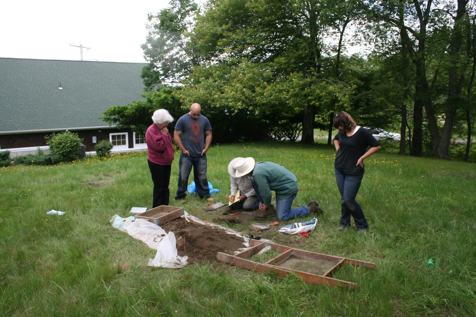
Also, see my article Digging Up The Past: Archaeology at the Old Quaker Meetinghouse, about Professor Morenon's excavation at the Quaker Cemetery and Meeting House site in the summer of 2013.

Public Lecture: “Hidden History: A Demonstration of GPR on the Quaker Cemetery" by Dr. Jon Marcoux, Salve Regina University
Saturday October 31 from 10 a.m.- 1 p.m. at Quaker Cemetery on Old Tower Hill Road (parking available at the Southern RI Chamber of Commerce)

Thursday, August 13, 2015

Reflecting on “Money I Have None:” Colonial Rhode Island’s Tradition of Negotiating Their Taxes and the Coming of the American Revolution"

"Money I Have None," the revision of the paper I presented at the New England Historical Association in the spring of 2013 ("₤200 Indet more then is Due Me:" Taxation and Negotiation in Colonial Rhode Island) is now up on Christian McBurney's Online Journal of Rhode Island History, smallstatebighistory.com.

As I was about to graduate after defending and submitting my MA thesis (with revisions) in 2011, I realized I needed to do more work on my C.V., which was practically non-existent at that time. I began trawling through the vast collection of notes for my MA thesis, looking for a story I could tell in about 10 double-spaced pages. There was a vignette I had developed in my MA thesis from some intriguing and perhaps unique sources that I literally stumbled across while looking for something else -- actual property lists generated by colonial-era taxpayers on the eve of the American Revolution (for an example of one these property lists, see image embedded in the tweet below). I thought a paper focusing on these might make a decent presentation at NEHA, especially since the tax records for those years also include some unique information regarding these same lists. I remember discussing this possibility with my thesis advisor Ron Dufour in the spring of 2012, as I was preparing to graduate. He was concerned that the topic "wasn't sexy enough," that it might be rejected or perhaps even worse, only attract a small handful of attendees at the conference. Which led me to post this slightly snarky tweet poking my advisor while I was responding to NEHA's CFP:


Fortunately, the topic was "um, yes" sexy enough to get accepted for the New England Historical Association's Spring 2013 Conference, and there was a decent turnout for the session at the conference. Entitled "Eighteenth-Century Political Economy," I was paired up with two other public historians, one presenting a biography about John Fisher's exploits during the American Revolution, and the other examining the effects of the Treaty of Utrecht on trade in northern New England. During his comments, session chair Dominic DeBrincat said my paper brought to light key procedures regarding colonial tax assessment, but suggested I try to make more explicit the links between the how local taxes were assessed and collected and the issues related to imperial taxation that boiled over in the American Revolution.

Granted, there were a lot of things I would have liked to have included in the NEHA paper -- it's amazing how being very strictly limited to a 10 page paper and a 20 minute presentation forces an economy of words -- a lot of interesting points are lost on the cutting room floor because there is simply no room, no time, for them. Still, his point was well-taken. Even in my MA thesis where I was not up against a 10 page limit, that point was lost in a sea of details, and it should have been the denouement of the NEHA paper.

That was the main revision I made in the new article -- to argue more forcefully that the top-down non-negotiable imperial taxation system put the British Empire on a collision course with Rhode Islanders locally assessed and negotiated tax system. Taxation without representation, or "virtual representation" (as British PM George Grenville referred to it) and away from Britain's long-standing policy of salutary neglect combined with Britain's 1751 currency regulations were anathema to Rhode Island's political economy. Local property-holders accustomed to negotiating their taxes either face-to-face with a tax assessor or justice of the peace, or through democratic localism -- viz-a-viz a majority vote at town meetings directing their deputies in the General Assembly -- were baffled and angered by the new taxation regime. These changes in tax policy, piled upon a new monetary policies that stressed Rhode Island's economy and a stricter policing of Atlantic trade, were cause for Rhode Islanders to first burn the H.M.S. Gaspee and then join the American Revolution. That point is made very clear made in this version of the paper.

♦ ♦ ♦

I recall reading (here and here) that outside of one's family and academic committee, most theses and dissertations are read by no more than three or four people. A depressing fact, given how many years and how much effort it takes to write one (in my case about seven summers, since I was a part-time graduate student and full-time teacher, and the only time the repositories of primary sources were open coincided with my work hours). Reciting "₤200 Indet more then is Due Me" to a roomful of historians at NEHA in 2013 probably enlarged the audience for that particular aspect of my thesis tenfold. But publishing it on Christian McBurney's blog has opened up opportunities to reach a comparatively vast new audience. The analytics seem to be down at the moment, but the last count I saw my paper on Small State Big History had been "viewed" over 60 times in less than a month of being posted. Even this humble blog has had (as of today, August 13, 2015) 31,121 views (!) in its four-year existence. As the anonymous author of the blog 100 Reasons NOT to Go to Graduate School points out:
"Typically, it takes months of research, writing, and revision to produce a journal article that will be seen by fewer people in its author's lifetime than will visit this blog in an hour."
Another point well-taken. If the purpose of public history is to reach and educate as much of the public as possible, then blogging would seem to be one of the best platforms today for that purpose. As a teacher for many years, I have passed along some modicum of historical lore to somewhere between two and three thousand individuals I've had as students. It is humbling to imagine that with the single act of starting this blog (which was also part of my plan to build up my C.V. in 2011) I have reached ten times as many people in four years as I have as a teacher for over 25. Similarly, posting 140-character history blurts on Twitter (in lieu of blogging about everything I find interesting here) has had a similar (if unpredictable) expansion of audience, as well as opening myself up to an entire network of historians (the so-called #Twitterstorians), and opportunities such as HistoryCamp.

Other opportunities to reach new audiences with this story of colonial taxation have presented themselves. As a smallstatebighistory author, I was invited to be interviewed by Bruce Newbury on the local talk radio station 1540 AM WADK Newport last month, and the station archived the interview as a podcast (which you can listen to here). Next Monday evening, several writers for the Online Journal of Rhode Island History (including Robert Geake, Russ DeSimone, Maureen Taylor, Tim Cranston, and myself) have been invited to Smith's Castle in North Kingstown for a panel discussion. We will be talking about our areas of historical interest related to our smallstatebighistory.com articles, our experiences writing history, and the future of writing vis-a-vis blogging.

It this last point, the significance of blogging (a key piece of what has become "digital history") that should be at least as interesting to talk about with these historians as discussing the finer points of Rhode Island History, particularly given that our audience at next Monday's roundtable will likely be only a fraction of the viewers we have had online. Blogging -- is it the future of public history? Given falling metrics for museum visits and declining membership in historical societies, it may very well be.

Saturday, June 20, 2015

Roman Britain on SlideShare

A couple of years ago I took a paper that I wrote for a graduate reading seminar on the history and archaeology Roman Britain and turned it into a three-week adult learning course at URI's Osher Lifelong Learning Institute (aka OLLI).

I had a lot of fun putting the class together. It was an opportunity to re-enter an area of interest that I came very close to making into a career at one time in my life. I made a blog for the class, put together handouts for class discussions primary and secondary sources, downloaded YouTube videos (no network connections in the room I was in; TY YOUTUBE DOWNLOADER) and reworked some notes from a Western Civilization course I taught into PowerPoint presentations (no network connections precluded using Prezis or other online presentation resources). The feedback I got for the course from my students was very positive; I still run into people that remember me for no other reason than they took the class and enjoyed it. I am planning to do some more Roman history classes at OLLI in the near future.

Unfortunately, I only "emailed myself" the notes for the first week; due to the lack of internet access I didn't send myself the other materials I used for the class, and a catastrophic hard drive failure later that fall meant that I lost the other PowerPoint I constructed for the class (I have been slowly getting better at backing up important stuff sooner rather than later, or in this case,, too late).

But I still have the presentation for the first class/week, and through the miracle of SlideShare, please enjoy the presentation for the first class of "A Brief History of Roman Britain"

Monday, July 29, 2013

Digging Up The Past: The Mystery of the Lost Filling Station

July 2, 2013 I was driving up Route 3, also known as Nooseneck Hill Road, in West Greenwich. As I was coming down the hill just before the bridge over the Big River I noticed a swarm of trucks and workers in fluorescent vests over on the left, where an old road that I had always assumed to be old Nooseneck Road comes out onto the main road (below). As I drove past, an excavator was pulling a huge old underground gasoline tank out of the ground. As long as I have known, there was never a gas station there, not even the hint of one. A piece of history – and a mystery! I immediately turned my car around and walked over. I introduced myself and struck up a conversation with an engineer from Resource Controls who was taking samples to check
for possible soil contamination. He said there had once been a gas station there, but that he had no idea what the station was or when it was in business. A worker from Western Oil Company joined our discussion. He said that earlier in the day there were town workers at the work site, and one of them told him that he had been in town since 1977, and as far back as he knew there was never any building on the site or evidence of a gas station. Based on the size of the tank, he doubted that it had been a little “mom and pop” station and estimated that the tank was anywhere from fifty to seventy years old. The engineer from Resource Controls suggested that the station went out of business when Route 95 came through, in a plot turn similar to that of the Disney Pixar film Cars. I mentioned that there was also a possibility the station was condemned as part of the Big River Reservoir project, but the engineer shook his head; he thought the gas station was probably gone before then.

While we were talking, the Western Oil Company excavator carried the empty gas tank and placed it on a large flatbed trailer; it was about to be hauled away by dump truck to Exeter Scrap Metal. I went home to get my camera, but the truck had already left by the time I got back. I followed the old tank to Exeter Scrap Metal, which recently moved a quarter-mile north of their old location, with a green metal scorpion out front that should give the “Big Blue Bug” in Providence a run for its money (above). The scrap yard folks were kind enough to let me photograph the old gasoline tank in its new digs (below, tank circled).


When I came back to the excavation site, the engineer from Resource Controls was discussing his soil samples with Angela Harvey, an engineer from DEM. She introduced herself to me and I told her I was from WRICHS with a historical interest in the business that had once been located there. She mentioned that the road we were standing next to was actually not an older section of Route 3, but rather was once known as Kitts Corner Road (left). When I asked Ms. Harvey about the former proprietors, like everyone I had spoken with she did not know who had operated the station or when it went out of business.

Then I mentioned that it may be possible that RIDOT’s bridge authority, which has an extensive photographic archive documenting state bridge-building for over a century, would have documented the construction of the nearby bridge over the Big River (this RIDOT photo archive was one the topics covered in “Over the River and Through the Woods: Bridges, Highways, and Public Works,” a workshop put on at the recent Rhode Island Preservation Conference in West Warwick in April 2013). Though the ceramic name and date tiles are no longer extant on the bridge (in fact, the bridge seems to be deteriorating rather badly at this point), it was almost certainly built in the latter 1930s during the Great Depression as part of the WPA. Maybe the bridge-building photos captured, off in the distance, an image of the gas station.

At that point Ms. Harvey told me about a historical resource I was not aware of. DEM has an extensive archive of aerial photographs of the entire state that date back to 1939, catalogued online using a GIS (Geographic Information System) program. I gave her my card and she agreed to send me information pointing me to DEM’s aerial photograph site. As promised, the next day she sent me a link to http://www.dem.ri.gov/maps. Her email instructed me to

“[s]imply scroll down to the fourth map selection (Topo Map & Aerial Photo Viewer), which will take you into the GIS program. Once you enter the viewer, type your address into the “find places” space located at the top right corner of the screen.”


I was able to navigate the map to the gas station locale simply by zooming in with my mouse wheel. On the upper left menu, by clicking the > symbol, the layers of the GIS map appear as a list. The default map that first appears is the “2011 Color” aerial map of Rhode Island; when the menu boxes for earlier maps are checked, the more recent map will gradually be replaced by the earliest map checked.

These aerial maps are a very intriguing resource. I have spent some time of late exploring the transformation of different parts of the state. Is some places, fields have turned into forest, while in many others the forest has been converted into houses and shopping centers. I recommend everyone go there and look at how much your neighborhood or other familiar locales have changed over the past 70 years.


These maps help answer some but not all of the questions regarding the gas station on Route 3. The journey back in time starts with DEM’s default map from 2011 – the area where the gas station was once located is circled. With the next image, we go back to 72 years, to 1939. Route 95 disappears, along with Big River Road, the road running parallel to 95 South on the 2011 map. Further to the west, Weaver Hill Road met directly with Kitts Corner Road to connect the hinterland with Nooseneck Hill Road. Focusing in on that triangular intersection, it appears to be heavily wooded – there is no gas station there or any other business, just woods – in 1939. A house can be seen in the photo in the cleared lot due west of the wooded triangle. Today, the lot is empty but still there is still a stone retaining wall running parallel with Route 3 where the house once stood.


The next set of aerial maps is from 1951. In this image, the gas station appears as a large square building casting its shadow to the north, in the triangle at the intersection of Nooseneck and Kitts Corner, about the same size as the house to west behind the retaining wall. Zooming out on the website map, it is clear that for many people living in the hinterland of West Greenwich, the best road out to Route 3 north was Kitts Corner Road. This gas station was likely the first one folks from the hinterland would pass on their way to work in the morning and last one they would go by on their way home. What about the residents of the house next to the station? Were they the proprietors of the station? Or did they lease or sell the triangle lot to a local mechanic or a franchise? There is no way to identify any details about the business from this image. Based on the size of the building, the station quite probably had a service bay to provide auto repairs; most gas stations at that time did that along with selling fuel, unlike today’s gas stations that only sell gas. Since the station was not in the 1939 aerial photographs, and due to gas rationing during World War II, it is also a safe bet to guess that the station was built sometime between 1945 and 1951. The business relied on travelers from Kitts Corner Road heading out to Route 3, which was at that time the main road through western Rhode Island to get to Providence, and to provide auto repairs to folks that might have broken down along Route 3. This probable construction date of after the war would also make it unlikely that any of RIDOT’s Depression-era photos of the construction of the Big River Bridge would incidentally show us more detailed images of the service station than the DEM aerial photographs.


In the aerial images from 1962, the arrival of Route 95 makes a profound change on the landscape. Kitts Corner Road, like many local roads and farms along the path of the interstate, is cut in two. The gas station building is still there, though it is impossible to tell from the photo whether it is still in operation. Further south outside the frame of the above photo, Route 3 and Route 95 become one for the next several miles south. In the next image ten years later (below), the gas station is clearly no longer in existence, though the outline of the parking lot is much clearer than in earlier images. The house in the lot due west of the former gas station is still there, though whether anyone was living there still is impossible to determine. Further south, Route Three and Route 95 were also separated out and ran parallel to each other rather than being combined together. As a commuter who uses Route 95 southbound to get to work, I can speak to the importance of having a second, parallel route to take when an accident has closed the interstate and the highway is backed up for miles.


By 1972, according to the April 2013 RIHPHC workshop, Route 95 had become a limited access highway; a bridge now carried the interstate over Weaver Hill Road, which became the new access point for the West Greenwich hinterland to reach Route 3, and access to 95 from Kitts Corner Road was closed off. As a youngster, I remember my father being able to get on and off the interstate at Switch Road in Richmond, but that at some point the state put up guardrails and berms to prevent people from getting on and off the highway from any of the old roads that once crossed Route 95. The only way to access the highway was at the numbered exits with on and off ramps. To this day, my father (who turned 88 back in March) still argues that Route 95 “ruined the area” by making it difficult for people in the vicinity of the highway to get around their own neighborhoods. But in the early 21st century, with the tremendous amount of infrastructure and bridge repair that needs to take place, we are probably fortunate that every minor laneway in use one hundred years ago was not given a bridge to go under or over the path of Route 95.


So the mystery remains. Who owned this gas station? Did the business fall prey of Route 95 and the attendant decline of traffic on Route 3 as a result of the people using the interstate to get to Providence? With far fewer cars going by on Nooseneck Road and none at all coming down Kitts Corner, this intersection was certainly no longer the “central place” it once was and may have lost its economic viability. But there is another possibility: the Big River Reservoir. The state first began consideration of damming the Big River to create another vast public water supply like the one in Scituate as far back as the 1920s. In the 1960s, at exactly the same time that the federal government was finishing the interstate highway system, Rhode Island began moving ahead with another major engineering project right in the same area as our mystery gas station.

“In 1964, the General Assembly, under the Big River-Wood River Acquisition Act, established a requirement for a bond issue of five million dollars…to be placed on the general referendum ballot. Having recently experienced the inconveniences and health hazard associated with several drought seasons, the voters passed the bond referendum. Under the powers of eminent domain, the state began acquiring property by condemnation beginning in Coventry in 1965, West Greenwich in 1966, and the in the Wood River area in Exeter in 1967…In the end, the state obtained a total of 8,600 acres from 351 owners which comprised 444 parcels at a cost of $7.5 million…”

--Excerpt from RI WATER RESOURCES BOARD,
BIG RIVER MANAGEMENT AREA POLICIES, July 1997


Without more information from either a WRICHS member that might remember this business, or a trip to the West Greenwich town clerk’s office to review the land evidence records, it is impossible to know whether the gas station closed in the early 1960s due to the changes in traffic flow because of Route 95 or in the later 1960s by eminent domain for the Big River Reservoir.

Either way, it seems that this gas station was not destined to remain in business into the 1970s. Today, Kitts Corner Road is just one of thousands of old back roads across the US impacted by directly or indirectly by the arrival of the interstate – once economically vital thoroughfares that are now bucolic roads to nowhere (below).

_________________________________________


NB: A version of this blog post also appears as a two-part article in the July and September bulletins of the Western Rhode Island Civic Historical Society, The Hinterlander.

Tuesday, July 2, 2013

Digging Up The Past: Archaeology at the Old Quaker Meetinghouse

This past June archaeology students from the Anthropology Department at Rhode Island College led by Dr. Pierre Morenon, undertook a study of the site of the former South Kingstown Society of Friends Meeting House and the adjacent Quaker Burial Ground. Sandwiched a bit uncomfortably between the ramp for the Wakefield exit for Route 1 South, the Southern Rhode Island Chamber of Commerce, the property is in the custody and care of the Pettaquamscutt Historical Society. The only remaining part of the site that is visible today is South Kingstown Historical Cemetery #90, the actual Quaker burial ground; above the surface there is nothing left of the old meeting house.

Inscriptions on graves in the burial ground next to the site of the meeting house date between 1714 to 1870. The site has a written history and provides archaeological evidence that dates back to at least the seventeenth century and likely before that. Less than a mile from here is the remains of a major Narragansett Indian town known as RI 110. While the town was likely abandoned in the wake of King Phillip's War (1675-6) if not earlier, certainly Native peoples traveled over and hunted on nearby site of the Quaker Meeting House before and after the Pettaquamscutt Purchase of 1657/8, and Narragansett people remained in the vicinity in the wake of the war. Quartz stone flakes found in the course of the June 2013 excavation by the RIC archaeologists offer clear evidence of the pre-European provenance of the site.

After the war, the settlement of Pettaquamscutt was rebuilt and English settlement of the region long-known as the "Narragansett Country" began with renewed vigor. Colonial English records indicate that in 1696, Nathaniel Niles bought a part of the Pettaquamscutt Purchase known as the “mill estate” for the sum of ₤200, which included most of the land that is today the village known as Wakefield, which has become the largest commercial center in South County. Based on the name of the purchase, apparently some kind of mill activity was already taking place along the Saugatucket River before Niles made his purchase, likely somewhere between the former textile mills on Main Street near the present day Saugatucket Bridge and Wakefield Elementary School on High Street, though no specific records of this earlier activity exists today. The Niles estate appeared in the 1703 survey of the King's Highway, which is today the Old Post Road or Scenic 1A.

Today Route 1 bypasses this compact area of Wakefield, where in the late seventeenth century and early eighteenth century, the King’s Highway wended down Sugarloaf Hill to end at the western bank of the Saugatucket River. There is no evidence there was bridge over the river at that early date, and travelers forded the usually shallow waters and picked up the road on the far bank. In 1698, about a mile away to the east of the ford Nathaniel Niles donated land for a meetinghouse for the Society of Friends. The meetinghouse was completed around 1700, and by 1710 the local Kingstown meeting was associated with local meetings in Providence, Cranston and Warwick via the monthly Quaker meeting in (East) Greenwich (see Map 1).

Beginning in 1743, the South Kingstown meeting house began hosting its own monthly meeting, and eventually came to be associated with local meetings in Richmond, Hopkinton and Westerly. The original meeting house was used by the local Society of Friends until fire destroyed the original meetinghouse for the Society of Friends in 1790; local Quakers met in the private homes of Benjamin Rodman and “Nailer Tom” Hazard until the meetinghouse was rebuilt in 1795.

In 1845, a schism emerged in the New England Society of Friends "between followers of Joseph John Gurney of England, who favored a more evangelical and pastoral route, and followers of John Wilbur of Hopkinton, R.I., who preferred a simpler unprogrammed form of worship." Despite calls for simplicity, the Quaker community had grown much larger over the course of two religious awakenings and the South Kingstown meeting became the monthly meeting site for Westerly, Richmond and Hopkinton meetings, while the number of Quaker meetings in Rhode Island had increased from 10 meetings in the early 18th century to 21 meetings by the 1830s (see Map 2).

The South Kingstown was a Wilburite meeting, and continued to meet at the same location in their rebuilt meeting house until the last quarter of the 19th century when the Quakers built a new meetinghouse about a mile away on Columbia Street and abandoned the site both for their meetings and as a burial ground.

The investigation by the RIC archaeologists sought to answer several questions about the both the meeting house to the west of the stonewall on the site and the cemetery, which lies to the east of the stone wall. The gravesites were mapped out and the distance between headstones and footstones were carefully measured. In this way, graves of children could be identified to help provide more data for infant and childhood mortality among this population, while for adults, ranges and averages for height could be determined. Test pits dug at regular intervals in the grassy area west of the stone wall located the site of the original meeting house that burned down in 1790; debris, broken window glass and 18th century nails helped identify the footprint of the Quaker hall, while further to the west quartz flakes found in the test pits suggest that Native Americans had touched up some stone tools in that same location. Another question still left to be answered is whether the stone wall was contemporaneous with the original meeting house. If it was, then test pits dug immediately to the east to the wall should be able to answer that question. If there is no debris from the fire, then the wall was there and retained the debris; if there is debris, then it is quite probable that the wall was built after the fire occurred.


This summer and fall, the archaeologists will continue to analyze the materials collected in their lab, where I hope to visit and follow-up on this investigation. Eventually, the report of the excavation will be given to the Pettaquamscutt Historical Society, and most of the artifacts (e.g., nails, glass, and other rubble) will be reburied on the site.


____________________________________________


Sources:

"Wakefield" in Lost South Kingstown: With a History of Ten of Its Early Villages. Kathleen Bossy and Mary Kean (editors), Kingston: Pettaquamscutt Historical Society, 2004.

Friends Meetings in New England, 1710. Guide to the Records of the Religious Society of Friends (Quakers) in New England) compiled by Richard D. Stattler New England Yearly Meeting Archivist, Published by the Rhode Island Historical Society, 1997, page 12.

Friends Meetings in New England, 1833. Guide to the Records of the Religious Society of Friends (Quakers) in New England) compiled by Richard D. Stattler New England Yearly Meeting Archivist, Published by the Rhode Island Historical Society, 1997, page 13.

The Dead Come To Life A glimpse into what lies beneath South Kingstown's Historical Cemeteries. http://narragansett.patch.com/groups/around-town/p/the-dead-come-to-life.